V2Vis application


V2Vis is a versatile app for presenting information from C-ITS communication to drivers. It displays important event data from V2X, received from RSUs or OBUs in vehicles nearby. Displayed alerts cover emergency vehicle approaching, speed limits, animals on the road, traffic lights etc. Users can also see their location on a map, view other vehicles and RSUs in the C-ITS network, and see allreal-time event locations. Stay informed and safe with V2Vis.
Contact us
In the ever-evolving landscape of transportation technology, staying connected and informed is paramount for road safety. This is where V2Vis steps in – application designed to display vital information from the C-ITS (Cooperative Intelligent Transport Systems) unit to the driver.
Application for drivers
The primary function of V2Vis is to display events received via V2X (Vehicle-to-Everything) communication. Notably, it goes beyond mere passive information display by allowing users to trigger the broadcast of various messages, serving as an alert system for surrounding vehicles.
The application is naturally optimized for various display sized and orientations. Nevertheless, the best user experience is achieved with a tablet. We have a solution for power control for the tablet, in case a permanent installation is required (the tablet is operated without a battery).
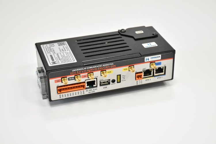
To get the information to display, the application communicates with connected the C-ITS OBU unit by Herman, requiring no other external systems. This makes it a robust and reliable tool for enhancing road safety. The application leverages Wi-Fi to connect seamlessly with the C-ITS unit
Informative notifications
V2Vis offers a range of notifications, each tailored to different types of events. These notifications are designed for clarity and user-friendliness, typically featuring road signs, distances to events, and relevant text. For instance, you can expect warnings for emergency vehicle passages, speed limits, fog, and obstacles like animals on the road. Additionally, V2Vis provides information about traffic lights for standard vehicles and tram drivers.
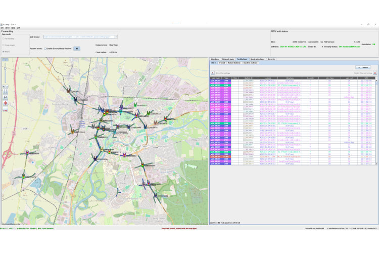
Map mode
In 'Map mode,' users can access a visual representation of their location on a map. This feature also highlights the positions of other vehicles and Roadside Units (RSUs) equipped with the C-ITS system. Furthermore, users can track the locations of received and currently active events, ensuring they have a comprehensive view of their surroundings.
By bridging the gap between C-ITS technology and drivers, it empowers motorists to stay informed, alert, and ultimately, safer on the road. With its user-friendly interface and array of functionalities, V2Vis is set to improve the way we approach road safety.